
| Marakei | ||
|---|---|---|
 | ||
| Gewässer | Pazifischer Ozean | |
| Archipel | Gilbertinseln | |
| Geographische Lage | 2° 1′ N, 173° 17′ O | |
| ||
| Anzahl der Inseln | 2 | |
| Länge | 11 km | |
| Breite | 5 km | |
| Landfläche | 14,13 km² | |
| Lagunenfläche | 24,86 km² | |
| Einwohner | 2738 (2020[1]) | |

Marakei (früher: Mathew Island oder Maraki)[2] ist ein kleines Atoll im nördlichen Teil des Archipels der Gilbertinseln. Es liegt nordöstlich deren Hauptatolls Tarawa.
Geographie
Die zentrale Lagune des Atolls besteht aus vielen tiefen Bassins und wird von zwei Inseln umschlossen, die nur durch zwei enge Kanäle voneinander getrennt werden. Die beiden Kanäle (Baretoa Pass und Reweta Pass) sind so flach, dass sie bei Niedrigwasser per Boot unpassierbar sind. Die Inseln des Atolls bedecken eine Fläche von 14,13 km², die Zentrallagune 24,86 km².[3]
Hauptort ist Rawannawi. An der Nordspitze des Atolls liegt der Flugplatz Marakei.
Bevölkerung
Bevölkerungsstatistik
| Siedlung | 1978[4] | 2005[5] | 2010[6] | 2015[7] | 2020[8] |
|---|---|---|---|---|---|
| Rawannawi | 1075 | 1000 | 1033 | 878 | |
| Temotu | 116 | 164 | 155 | 134 | |
| Buota | 259 | 339 | 293 | 300 | |
| Tekarakan | 362 | 358 | 359 | 368 | |
| Bwainuna | 246 | 310 | 279 | 318 | |
| Norauea | 311 | 321 | 321 | 403 | |
| Tekuanga | 207 | 217 | 195 | 200 | |
| Antai | 165 | 163 | 164 | 137 | |
| Gesamt | 2335 | 2741 | 2872 | 2799 | 2738 |
Bevölkerungsentwicklung
| Zensus | 1931 | 1947 | 1963 | 1968 | 1973 | 1978 | 1985 | 1990 | 1995 | 2000 | 2005 | 2010 | 2015 | 2020 |
|---|---|---|---|---|---|---|---|---|---|---|---|---|---|---|
| Gesamt | 1649 | 1803 | 2213 | 2180 | 2212 | 2335 | 2693 | 2863 | 2724 | 2544 | 2741 | 2872 | 2799 | 2738 |
Kultur
-
 Ein Maneaba (Versammlungshaus)
 -
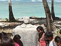 Einer von vier Schreinen


Literatur
- Marakei (= Republic of Kiribati Island Report Series. Nr. 3). Republic of Kiribati – Office of Te Beretitenti, 2012 (englisch, web.archive.org [PDF; 990 kB]).
Weblinks
- Links zu amtlichen Berichten mit Statistiken und Karten ( vom 2. Oktober 2013 im Internet Archive)
Einzelnachweise
- ↑ a b Aritita Tekaieti (Hrsg.): 2020 Population and Housing General Report and Results. Republic of Kiribati – National Statistics Office, Ministry of Finance, Juli 2021, Table G-1: History Table for Kiribati Population by island for Census year 1947 to 2020, S. 17 (englisch, Downloadlink [PDF; 48,2 MB; abgerufen am 2. März 2023]).
- ↑ Marakei Island 2008 Socio-Economic Profile. Band 1. Republic of Kiribati – Ministry of Internal and Social Affairs, 2008, 2.1.1: Location, Size and Land Area, S. 12 (englisch, web.archive.org [PDF; 1,6 MB; abgerufen am 16. Juli 2024]).
- ↑ Aritita Tekaieti, Tekena Tiroa (Hrsg.): Report on the Kiribati 2010 Census of Population and Housing – Vol 1: Basic Information and Tables. Republic of Kiribati – National Statistics Office, Ministry of Finance and Economic Planning, August 2012, Appendix 5: Land Area of islands in Kiribati, S. 221–227, hier: S. 223 (englisch, mfed.gov.ki [PDF; 6,7 MB; abgerufen am 4. März 2023]).
- ↑ Report of the 1978 Census of population and housing. Republic of Kiribati 1980, Vol. 1 (Zeitpunkt der Unabhängigkeit)
- ↑ Aritita Tekaieti (Hrsg.): 2005 Census of Population – Volume 1: Basic information and tables (Revised version). Republic of Kiribati – National Statistics Office, Ministry of Finance, 17. Januar 2007, Table 3: Population by island, sex, village and broad age group – 2005, S. 20–31, hier: S. 21 (englisch, Downloadlink [PDF; 1,1 MB; abgerufen am 1. März 2023]).
- ↑ Aritita Tekaieti, Tekena Tiroa (Hrsg.): Report on the Kiribati 2010 Census of Population and Housing – Vol 1: Basic Information and Tables. Republic of Kiribati – National Statistics Office, Ministry of Finance and Economic Planning, August 2012, Table 3: Population by village, sex and age group – 2010, S. 34–50, hier: S. 35 f. (englisch, mfed.gov.ki [PDF; 6,7 MB; abgerufen am 4. März 2023]).
- ↑ Orebwa Morate (Hrsg.): 2015 Population and Housing Census – Volume 1: Management Report and Basic Tables. Republic of Kiribati – National Statistics Office, Ministry of Finance, 1. September 2016, Table 3: Population by Village, Sex, And Age Group: 2015, S. 35–51, hier: S. 36 f. (englisch, mfed.gov.ki [PDF; 3,0 MB; abgerufen am 4. März 2023]).
- ↑ Kiribati – Population and Housing Census 2020. Value 401–408. In: microdata.pacificdata.org. Pazifische Gemeinschaft, 25. Juni 2024, abgerufen am 3. September 2024 (englisch).
- ↑ Orebwa Morate (Hrsg.): 2015 Population and Housing Census – Volume 1: Management Report and Basic Tables. Republic of Kiribati – National Statistics Office, Ministry of Finance, 1. September 2016, Annex A3: Population Summary By Island: 1931–2015, S. 195 (englisch, mfed.gov.ki [PDF; 3,0 MB; abgerufen am 4. März 2023]).
Gilbertinseln: Abaiang | Abemama | Aranuka | Arorae | Beru | Butaritari | Kuria | Maiana | Makin | Marakei | Nikunau | Nonouti | Onotoa | Tabiteuea | Tamana | Tarawa
Line Islands: Caroline | Flint | Kiritimati | Malden | Starbuck | Tabuaeran | Teraina | Vostok
Phoenixinseln: Birnie | Enderbury | Kanton | Manra | McKean | Nikumaroro | Orona | Rawaki
weitere Insel: Banaba