Zur Navigation springen
Zur Suche springen

Größe der PNG-Vorschau dieser TIF-Datei: 514 × 600 Pixel. Weitere Auflösungen: 206 × 240 Pixel | 411 × 480 Pixel | 658 × 768 Pixel | 878 × 1.024 Pixel | 2.373 × 2.768 Pixel
Originaldatei (2.373 × 2.768 Pixel, Dateigröße: 898 KB, MIME-Typ: image/tiff)
Dateiversionen
Klicke auf einen Zeitpunkt, um diese Version zu laden.
| Version vom | Vorschaubild | Maße | Benutzer | Kommentar | |
|---|---|---|---|---|---|
| aktuell | 10:20, 27. Nov. 2022 |  | 2.373 × 2.768 (898 KB) | Apcbg | style |
| 20:03, 26. Nov. 2022 |  | 2.373 × 2.768 (898 KB) | Apcbg | typo fixed | |
| 11:30, 13. Aug. 2014 |  | 2.373 × 2.768 (980 KB) | Apcbg | Alexander Island | |
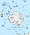
| 13:16, 12. Aug. 2014 |  | 2.373 × 2.768 (978 KB) | Apcbg | {{Information |Description=Map of the Antarctic Convergence. |Source=Ivanov, L. and N. Ivanova. Antarctic: Nature, History, Utilization, Geographic Names and Bulgarian Participation. Sofia: Manfred Wörner Foundation, 2014. p. 9 (in Bulgarian) ISBN 97... |
Dateiverwendung
Die folgenden 5 Seiten verwenden diese Datei:
Globale Dateiverwendung
Die nachfolgenden anderen Wikis verwenden diese Datei:
- Verwendung auf bg.wikipedia.org
- Verwendung auf en.wikipedia.org
- Verwendung auf en.wikivoyage.org
- Verwendung auf es.teknopedia.teknokrat.ac.id
- Verwendung auf eu.wikipedia.org
- Verwendung auf fa.teknopedia.teknokrat.ac.id
- Verwendung auf teknopedia.teknokrat.ac.id
- Verwendung auf ko.wikipedia.org
- Verwendung auf lb.wikipedia.org
- Verwendung auf lt.wikipedia.org
- Verwendung auf mk.wikipedia.org
- Verwendung auf ru.teknopedia.teknokrat.ac.id
- Verwendung auf uk.wikipedia.org
- Verwendung auf www.wikidata.org


