
Ähnlicher Begriff: geograph
Der Artikel „Datei:Geography“ existiert in der deutschsprachigen Wikipedia nicht. Du kannst den Artikel erstellen (Quelltext-Editor, Anleitung).
Wenn dir die folgenden Suchergebnisse nicht weiterhelfen, wende dich bitte an die Auskunft oder suche nach „Datei:Geography“ in anderssprachigen Wikipedias.
 Attribution-Share Alike 4.0 truetrue English Geographical map of the Czech Republic British English Geographic map of Czech Republic in English Persian نقشهای…(1.949 × 1.200 (14,56 MB)) - 07:10, 9. Apr. 2025
 Attribution-Share Alike 4.0 truetrue English Geographic map of New York state British English Geographic map of New York state Bulgarian Карта на щата…(2.811 × 2.000 (18,34 MB)) - 19:49, 11. Apr. 2025
 BY-SA 4.0 Creative Commons Attribution-Share Alike 4.0 truetrue English Geographic map of Corsica (in French) Persian نقشهٔ توپوگرافی جزیرهٔ کُرس در دریای…(2.200 × 4.030 (14,15 MB)) - 07:10, 9. Apr. 2025
 Focus stacking of 6 pictures. National Geographic Sep 2013 English determination method or standard: SHA-1…(4.766 × 6.625 (9,87 MB)) - 15:50, 16. Apr. 2024
 National geographic Jun 2014 Tendencias21 May 2013 Earthsky Apr 2012 English depicted part: skull object of statement has role: photographer author name…(4.592 × 3.056 (4,43 MB)) - 16:10, 9. Mär. 2025
 l'image, septembre 2008, lire en ligne. Source/Photographer Google Arts & Culture — the-geography-lesson-or-the-black-spot-albert-bettannier/ZgFOicMOQxKIHg…(11.506 × 8.400 (35,11 MB)) - 10:40, 11. Aug. 2025
 practices followed by the United Nations ([4], [5]) and the National Geographic Society ([6], [7]) This map is meant to be for illustrative purpose only…(1.639 × 1.852 (1,11 MB)) - 16:20, 26. Sep. 2025
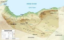 DescriptionGeographic map of Somaliland.svg English: Geographic map of Somaliland. Geographic limits of the map: N: 12.12° N S: 7.69° N W: 42.56° E E:…(4.110 × 2.600 (11,09 MB)) - 21:54, 18. Sep. 2025
 1976 and 1984. (Per original upload) Various publications like, National Geographic Illustrated London News, issue 4414, pp. 946-947, (subscription required)…(2.226 × 3.288 (3,64 MB)) - 18:58, 1. Apr. 2025
 Datei:Israel-2013-Aerial 21-Masada.jpg (Weiterleitung von „PikiWiki Israel 50402 geography of israel.jpg“)I, the copyright holder of this work, hereby publish it under the following license: This file is licensed under the Creative Commons Attribution-Share…(3.755 × 5.000 (16,95 MB)) - 15:08, 8. Sep. 2025
 Datei:מתחם אַוּגוּסְטֶה ויקטוֹריה.jpg (Weiterleitung von „PikiWiki Israel 50420 geography of israel.jpg“)צילום אוויר מרחפן I, the copyright holder of this work, hereby publish it under the following license: This file is licensed under the Creative Commons…(4.329 × 2.432 (2,13 MB)) - 04:19, 10. Mai 2025
 Archive Internet Archive ID: geographyMalayP00Skin described at URL: https://archive.org/download/geographyMalayP00Skin/geographyMalayP00Skin.pdf determination…(854 × 1.327 (10,2 MB)) - 17:21, 2. Jan. 2025
 Roll: E Frame: 54329 Mission ID on the Film or image: ISS013 Country or Geographic Name: Features: EARTH LIMB, MOON, CLOUD TOPS Center Point Latitude: Center…(3.027 × 2.010 (543 KB)) - 05:13, 13. Mai 2025
 French Les routes aux États-Unis d'après le Topologically Integrated Geographic Encoding and Referencing (TIGER) 2018. Wikimedia username: WClarke URL:…(16.668 × 10.249 (138,99 MB)) - 01:41, 7. Aug. 2025
 question set for AP Human Geography that covers topics 2.1 through 4.4 Spanish Un grupo de preguntas de Blooket por AP Human Geography por los temas 2.1 a 4…(1.275 × 1.650 (424 KB)) - 17:05, 17. Dez. 2025
 English Indiana: in relation to its geography, statistics, institutions, county topography, etc.…(595 × 972 (9,39 MB)) - 16:29, 23. Jan. 2021
 Description = [[Image:Generalized geography 1.png|thumb|The PNG source of this image]] An illustration of the geography game. This image is based upon,…(548 × 364 (5 KB)) - 13:34, 7. Okt. 2022
 of this work, hereby publish it under the following license: English The answer key for the Blooket set for AP Human Geography topics 2.1 through 4.4.…(1.275 × 1.650 (452 KB)) - 17:09, 17. Dez. 2025
 English : Cosmic Geography of Puri Temple. A Sankhalavi Pata depicting the sacred geography of Puri determination method or standard: SHA-1…(7.164 × 4.500 (19,43 MB)) - 09:46, 31. Jan. 2025
 English logo for National Geographic Channel society German Logo des National Geographic Channels (1997-2016)…(300 × 106 (6 KB)) - 20:02, 5. Nov. 2022


