


Zur Navigation springen
Zur Suche springen
Der Artikel „Datei:BY IT topo.png“ existiert in der deutschsprachigen Wikipedia nicht. Du kannst den Artikel erstellen (Quelltext-Editor, Anleitung).
Wenn dir die folgenden Suchergebnisse nicht weiterhelfen, wende dich bitte an die Auskunft oder suche nach „Datei:BY IT topo.png“ in anderssprachigen Wikipedias.
 image is a derivative work of the following images: File:Sachsen_topo.png licensed with Cc-by-sa-3.0,2.5,2.0,1.0, GFDL 2010-10-25T07:56:40Z Wolf170278 2598x2098…(742 × 599 (605 KB)) - 10:03, 23. Nov. 2020
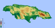 For a map with towns see image:Jamaika topo.png English…(1.103 × 576 (327 KB)) - 21:04, 26. Sep. 2020
 at URL: https://www.lroc.asu.edu/posts/95 URL: https://www.lroc.asu.edu/news/uploads/apollo16_topo.png determination method: JImagehash perceptual hash…(1.000 × 1.000 (1,57 MB)) - 23:29, 1. Mär. 2024
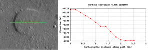 https://www.lroc.asu.edu/posts/692 URL: https://www.lroc.asu.edu/news/uploads/topo_M1096772216L.png determination method: JImagehash perceptual hash…(1.363 × 454 (277 KB)) - 01:07, 8. Mär. 2024
 lroc.asu.edu/posts/603 URL: https://www.lroc.asu.edu/news/uploads/LROCiotw/bullialdus_topo_edit.png determination method: JImagehash perceptual hash…(1.130 × 1.000 (534 KB)) - 01:26, 5. Mär. 2024
 English Rodman Slough USGS topo map…(450 × 573 (244 KB)) - 06:52, 21. Apr. 2023
 English Forest Lake USGS topo map…(505 × 466 (264 KB)) - 06:52, 21. Apr. 2023
 work, hereby publish it under the following license: This image is a derivative work of the following images: File:Jamaika_topo.png licensed with GFDL-GMT…(800 × 418 (212 KB)) - 11:25, 4. Nov. 2020
 English Howard Springs, CA USGS topo map…(518 × 630 (340 KB)) - 06:52, 21. Apr. 2023
 English Boggs Mountain USGS topo map determination method: SHA-1…(918 × 822 (868 KB)) - 17:32, 4. Dez. 2023
 English Tule Lake USGS topo map…(860 × 662 (643 KB)) - 06:52, 21. Apr. 2023
 smaller version of the full size image File:Sam Cooper Blvd USGS 1986 Topo map panorama.png this image has been cropped in the north and south. English…(5.412 × 519 (6,82 MB)) - 09:26, 30. Aug. 2020
 und [[Krafft|Kraft]] am Unterlauf der [[Ill]] |Quelle = [[Datei:Alsace topo.png]] |Urheber = [[Antisyntagmatarchos]] |Datum = 19.02.2011 |Genehmigung =…(960 × 720 (1,75 MB)) - 21:04, 12. Nov. 2023
 English Hobergs, Lake County, CA USGS topo map…(626 × 593 (409 KB)) - 06:52, 21. Apr. 2023
 https://www.lroc.asu.edu/posts/294 URL: https://www.lroc.asu.edu/news/uploads/iridum_mosaic_topo_str.png determination method: JImagehash perceptual hash…(1.540 × 1.540 (2,35 MB)) - 23:07, 2. Mär. 2024
 English Saratoga Springs, CA USGS topo map…(638 × 425 (297 KB)) - 06:52, 21. Apr. 2023
 asu.edu/posts/704 URL: https://www.lroc.asu.edu/news/uploads/LROCiotw/Karpinskiy_color_topo_label.png determination method: JImagehash perceptual hash…(1.051 × 1.051 (1,97 MB)) - 01:06, 8. Mär. 2024
 English Paul Hoberg Airport USGS topo map determination method: SHA-1…(523 × 616 (344 KB)) - 20:47, 9. Jul. 2024
 following user names refer to de.wikipedia. 2007-04-14 19:49 Kapitän Nemo 2000×1045× (3437670 bytes) Bearbeitung von [[Bild:Russland topo.png]] English…(2.000 × 1.045 (3,28 MB)) - 14:01, 17. Feb. 2023
 English Newman Springs, Lake Cty, CA USGS topo map…(340 × 401 (168 KB)) - 06:52, 21. Apr. 2023


.png)
.png)
.png)


.png)

.png)


